Unlock location intelligence with Map & Geo Analytics
Our geospatial analytics turns static reports into interactive, location-aware insights—so you can map trends, optimize operations, and make smarter, data-driven decisions.

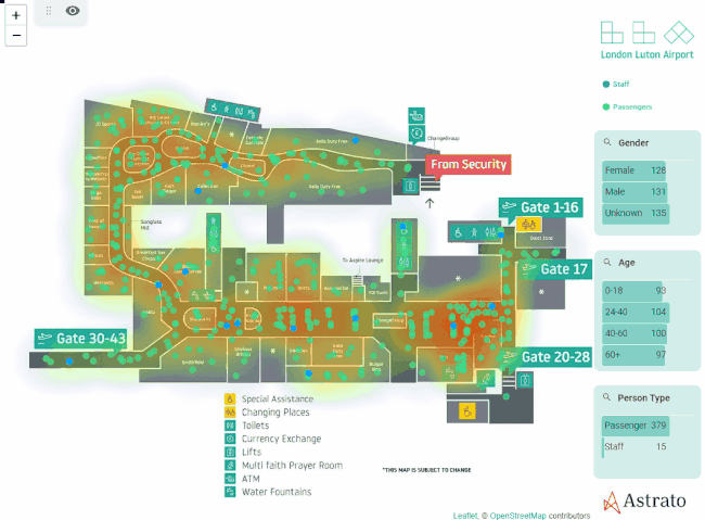
See your data in a whole new dimension
Map your data to uncover hidden patterns that traditional BI can’t show.
Optimize logistics, sales territories, and operational planning with real-time geospatial insights.
Filter, zoom, and drill down into locations to explore trends dynamically.
Powerful location intelligence without the usual complexity
Most BI tools make geospatial analysis feel like rocket science. Astrato makes it effortless. With a drag-and-drop interface, real-time cloud connections, and fully interactive maps, you can visualize, filter, and explore location-based trends without needing GIS expertise.


.png)
Track movement & connections with Flow Maps
With Astrato’s Flow Maps, you can visualize movement patterns, relationships, and connections between locations—all powered by live cloud data.
Whether you're tracking supply chains, migration trends, or digital networks, Flow Maps help you see how things move—not just where they are.
Popular use cases for geospatial analytics
Optimize store locations, analyze regional performance, and improve delivery routes.
Track fleet movements, identify bottlenecks, and streamline distribution.
Understand regional demand, target ads based on location data, and map customer trends.
Assess fraud risk, track economic trends, and monitor financial performance by geography.
Identify high-value locations, analyze foot traffic, and optimize infrastructure development.
Track disease outbreaks, optimize healthcare facility locations, and analyze patient demographics for better resource allocation.